Title here
Summary here
February 10, 2021 in Aerospace, Navigation by ![]() Dhulkarnayn—5 minutes
Dhulkarnayn—5 minutes
Imagine finding yourself in an unfamiliar city for an important interview, relying solely on a cab driver or directions from strangers due to the absence of a GPS-enabled device. The potential pitfalls—delays, missed opportunities, and heightened stress levels—are numerous, underscoring the critical role of Global Positioning System (GPS) technology in our daily lives, particularly in navigation and location-based services.
Image Credits: Location illustrations by Storyset
Have you ever considered the challenges and implications of traveling without a smartphone or GPS device?
As technology continues to evolve, drones have emerged as a transformative innovation, revolutionizing various industries, including logistics, agriculture, and surveillance. Central to the efficiency and effectiveness of drones is their ability to navigate accurately and autonomously, a capability significantly influenced by GPS technology.
This post delves deeper into the integral relationship between drones and GPS, exploring its evolution, applications, and impact on aerospace advancements. By unraveling the complexities and nuances of this relationship, we can gain valuable insights into the future possibilities and innovations in drone technology and navigation systems.
The Global Positioning System (GPS) is a satellite-based radio navigation system that provides accurate location and time information to users worldwide. Originally developed for military applications, GPS has become an indispensable technology, revolutionizing various industries, including transportation, agriculture, and aerospace.
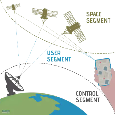
Image Credits: Dhulkarnayn, Elucidate Drones
The Global Positioning System consists of three major segments:
Before understanding the role of GPS in drone navigation, it is essential to clarify the three segments of GPS. Therefore, I’ve provided brief explanations of each segment below.
The Space Segment encompasses a constellation of 24 to 32 satellites orbiting the Earth at an altitude of approximately 20,200 km. These satellites continuously transmit signals containing precise time and location data, empowering users equipped with GPS receivers to determine their exact geographic location, speed, and altitude with unparalleled accuracy and reliability.
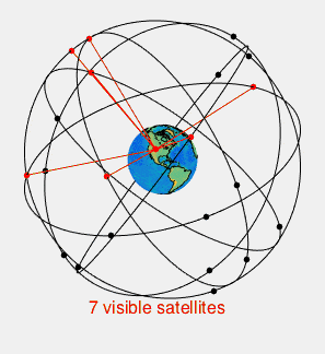
Interestingly, a constellation of just twenty-one satellites is sufficient to ensure global coverage, with the remaining satellites serving as reserves to maintain optimal system performance and reliability.
The redundancy inherent in the GPS system allows a GPS receiver to triangulate its position using signals from as few as four satellites, illustrating the system’s robustness and resilience against potential failures or disruptions.
The Control Segment serves as the backbone of the Global Positioning System (GPS), comprising a network of ground-based monitoring stations and control centers meticulously designed to oversee, manage, and maintain the operational integrity and accuracy of the GPS satellite constellation.
As mentioned in Introduction to Avionics Systems, by R.P.G. Collinson,
The control segment tracks the satellites and predicts their future orbital position data and the required satellite clock correction parameters, and updates each satellite on the uplink as it goes overhead.1
The Master Control Station (MCS) coordinates satellite activities, ensuring accurate positioning and synchronization through continuous monitoring and updates.
Dedicated ground monitoring stations track satellite orbits, transmit critical data to the MCS, and support precise orbit determination and error correction.
Image Credits: Bubba73 at English Wikipedia / CC BY-SA
Secure and efficient data communication networks facilitate seamless communication between the MCS, ground stations, and satellites, ensuring reliable system operation and protection against vulnerabilities.
The User Segment encompasses a vast array of devices equipped with GPS receivers, facilitating diverse applications in our daily lives and various industries.
Image Credits: App illustrations by Storyset
From smartphones and ATMs to aircraft, cars, and military vehicles, the ubiquity of GPS receivers is evident. For instance, over 1 billion people use Google Maps, highlighting the extensive use and importance of GPS receivers in navigation and location-based services.
Additionally, these receivers support a myriad of other applications, underscoring their versatility and integral role in modern technology and infrastructure.
Let’s contemplate a scenario to understand the role of GPS in drone navigation. Consider that you’ve ordered a product online, and it is going to be delivered by a drone.
Image Credits: Technology illustrations by Storyset
After knowing that the product is going to be delivered by a drone, several questions may arise:
How will the drone navigate to my location and How will it select the path, etc.,?
The primary answer to these questions is the Global Positioning System (GPS). The navigation of the drone primarily relies on GPS receivers integrated into the drone, and path planning algorithms (dependent on GPS) are responsible for selecting the route the drone needs to travel.
Although GPS offers significant advantages, such as worldwide coverage, it also has some limitations, including multi-path propagation, clock data error, natural & artificial interference, etc.
Image Credits: Technology illustrations by Storyset
The inaccuracies caused by these issues can be mitigated by integrating GPS with other navigation systems. For example:
Did you know?
The integration of multiple navigation systems with proper filtering schemas provides better accuracy compared to a single system.
In conclusion, this post has endeavored to elucidate the intricate relationship between drones and GPS, shedding light on its evolution, capabilities, and integration with other navigation systems. Your feedback and insights are invaluable to us, and we encourage you to share your thoughts in the comments section below.
Sharing is caring! If you found this article insightful, feel free to share it with your friends, colleagues, and networks. Thank you for your continued support and engagement!
This post is licensed under Creative Commons Attribution-ShareAlike 4.0 International (CC BY-SA 4.0) by the author.
Please consider supporting this project!
If this article has been of help to you, and you feel generous at the moment, don’t hesitate to buy us a coffee. It's an easy, fun and direct way to show your support — any amount of coffee is highly appreciated.